
|
It’s Hot In Those Hills
By Joyce Schifanelli — Wednesday, August 6th, 2008
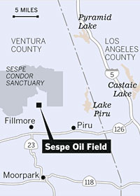 Location of the Hot Spot The ground is sizzling with temperatures rising as high as 812 degrees on a two-acre patch of land in the hills north of Fillmore. Nearly seven weeks ago, firefighters responded to reports of fire and a smoky haze along the parched terrain; however, upon inspection, they encountered no flames, only smoldering dirt and brush. According to other news sources, including the Ventura County Star, the Los Angeles Times, and Fox News, the smoking “hot spot” in the Ventura County section of Los Padres National Forest continues to puzzle firefighters and geologists even after weeks of monitoring. “It’s a thermal anomaly,” said Ron Oatman, spokesperson for the Ventura County Fire Department. David Panaro, a participating geologist with the Ventura County Watershed Protection Agency said, “This is not your usual geological detective story.” Geologists and firefighters surveyed the area, located in the Sespe Oil Field, but they have not made a definitive determination of what is causing the intense heat. Nevertheless, they do have a theory that does not include human activity. The “hot spot” is in an active landslide zone with a history of shifting for more than sixty years. Pockets of gas, tar and oil lie several hundred feet below its cracked surface. Allen King, a retired geologist with the U.S. Forest Service visited the site on Friday, August 1. In his opinion, the smoking ground is “a normal occurrence”. He explained that cracks along the landslide’s slope allow oxygen to enter the earth, and those natural hydrocarbon materials (gas, tar and oil) to “seep out” of the fine-grain shale. Underground combustion is a possible result, and could be as deep as 100 feet. Since 1987, high heat levels have been recorded in the area as many as five times. “Hot spots” are not uncommon in areas around the world with high concentrations of hydrocarbons. The 812 degree temperature, taken last Friday, was measured about a foot below the surface. The depth of hydrocarbon materials “varies tremendously,” says King, also acknowledging that he does not know at what depth combustion is occurring in the oil field. Smoke rose through five cracks in the ground as firefighters cleared brush, and cut a fire line around the area as a precautionary measure. Oatman said that fire officials predict the smoke will come and go until the next heavy rain, when fissures are plugged with water and mud. The U.S. Bureau of Land Management owns the acreage (near the Sespe Oil Field), and leases it to Seneca Resources Corp. The rugged, steep terrain is devoid of buildings and equipment, and gated off from public access. The 3,000 acre Sespe Oil Field, producing nearly 50 million barrels of oil since its discovery in 1887, contains more than 300 oil wells, of which 210 are active. Although Jeff Kuyper, Executive Director of the Los Padres Forest Watch expressed his deep concern on the potential effects of the “hot spot” on the nearby Condor Sanctuary and the forest’s fire prone environment, the Ventura County Fire Department continues to monitor the area daily and does not consider the “hot spot” to be a threat to public safety. Story from CBS2/KCAL 9 Los Angeles |