
|
FEMA flood insurance meeting draws hundreds of residents
 By Wanda Castel de Oro — Wednesday, October 28th, 2009
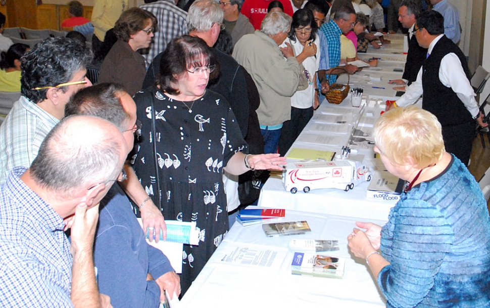
Fillmore Veterans Memorial building came alive last Thursday night, October 22, as several hundred residents came to ask the Federal Emergency Management Agency (FEMA) why it was requiring flood insurance on approximately 1,500 Fillmore homes. The informational meeting was hosted by Bert Rapp, Fillmore’s Director of Public Works, FEMA’s Ed Curtis, Region IX Engineer, and FEMA flood insurance expert Jana Crutchfield. Rapp began the evening with a history of flood occurrences in Fillmore and a PowerPoint explanation of the area’s prospective flood areas. He explained the recertification process for all levees in the United States, which are reviewed every five years for reaccreditation. But the spirit of the evening was in the questions and concerns of the citizens who came to the microphone to express those concerns. Paul Schifanelli spoke on behalf of the elderly who live at the El Dorado Mobile Home Park. Resident Joel Quintero encouraged the county to question FEMA’s rezoning. Diane Scoggins drew one of the few laughs of the evening when she said her house was in the flood zone, but not her backyard, and wondered if she could get half the insurance needed. David Reeves question the financial impact on not only the individual homeowner but the greater cost to the community in levee retrofitting. Rapp answered his question with a breakdown of subsidy involving grants and builder funding. He explained how two-dimensional studies are used for real behavior of the water, whereas one-dimensional studies were used in 1979, after the 1978 Los Serenos flood. During the storms of February 5-ll, l978, the peak flow of record, 73,000 cu ft/s, occurred in Fillmore. Overbank flow was negligible, but more than l0 feet of sediment was deposited in the channel along the lower reach of the Sespe (approx. two miles). On March 4, l978, a peak flow of 54,000 cu ft/s broke out of the sediment-laden channel, causing a major flood. Tons of silt and debris were carried into over 370 homes. There was one fatality and structural damage to 200 homes from floodwaters. Total damages to the Los Serenos area were estimated to be $6.2 million. Before answering the public’s concerns, Rapp reviewed the status of Fillmore’s levees: Upper Sespe Creek levee, maintained by the Ventura County Watershed Protection District (VCWPD); a new levee for the Business Park, and the new Water Reclamation Plant (owned by the city of Fillmore); Riverwalk levee, new Heritage Valley Bridges levee (under construction); levees around Pole Creek basin; and Pole Creek Channel, owned and operated by VCWPD. The soundwall constructed by The Bridges development along Hwy 126 also serves as a flood wall. Currently, upper Sespe Creek levee is being reaccredited so that none of north Fillmore falls into Flood Zone A, ie: area of special flood hazard without water surface elevations determined. That is the “good news”, according to Rapp. However, the one-mile levee downstream of the Sespe is in need of retrofitting, and will not be accredited. Levee protection at the Business Park and Water Reclamation Plant cannot be accredited until the upstream levee is certified. Heritage Valley Bridges community could be accredited as early as the next 3-6 months. Pole Creek is much further into the future, stated Rapp. The Sespe levee is considered as non-existent; FEMA runs their tests as if the Sespe Creek levee doesn’t exist, said Rapp. A theoretical Sespe Creek flood overflow is studied to help determine flood zoning. The lower Sespe Creek levee will be retrofitted in the next 3-10 years, contingent on available monies. Heritage Valley levee could take six months to years, Pole Creek Debris Basin will be driven by the economy, said Rapp. For now it is “on hold”, offering a temporary basin. Pole Creek channel is contingent on the Steelhead passage issue, and funding. It falls under the canopy of the VCUWD and could take 6-12 years or longer. Rapp stressed the increased flood flow since the 1978 Los Serenos flood, which devastated areas of Fillmore. He said there have been six large flood flows between 1979 and 2009. Riverbed scouring and aggregation, rock and debris build-up, are also factors in FEMA’s re-zoning effort, as is local erosion, and active channel changes with major storm events. Rapp said there has been a 35% increase in flow compared to the 1979 analysis, with a shift of dominant channel from the west to east fork. “The river is alive, it is not fixed,” stated Rapp. Rapp laid out the exhaustive process of zoning and accreditation which involves the VCUWD, the Army Corps of Engineers, FEMA, EIR report, and funding. FEMA does not project rainfall, or consider global warming and other factors when deciding flood zone changes; they only consider history of the area, according to Rapp. Ed Curtis, a FEMA Region IX Engineer, spoke briefly and took several questions. He stated that on January 20, 2010 flood maps for the entire county go into effect. A letter of final determination will be issued by FEMA. He said FEMA considers mapping identification of flood hazards, insurance requirements, reduction of economic impacts, floodplain management, and building practices aimed at reducing flood damage. An unidentified resident expressed concern over a 400 foot gap in the Santa Clara levee, south of the Hwy 23 bridge, leading to Grimes Canyon. The gentleman asked, “Why are you accrediting the Riverwalk levee?” Curtis said he and an attending colleague were “not familiar with the circumstance of that situation.” He said if more information could be provided, FEMA would take it into consideration. The area had flooded several years ago and there was concern that the flooding could also extend to the north side of the bridge, involving the Riverwalk housing tract. Closing the evening was Jana Crutchfield, a FEMA flood insurance specialist out of Oakland. She provided information on how to save money on flood insurance by buying early (before the January 20, 2010 cutoff) before map changes take effect. Crutchfield said residents can “grandfather” in, using existing flood maps, good for one year. Then rates will adjust upward to reflect the zoning changes taking place after the January deadline. The purchased policy must be maintained to be kept in continuous force. There is a 30-day period of application after insurance has been purchased. Crutchfield recommended buying flood insurance no later than December 19, 2009 to take advantage of the grandfather clause. If residents living in flood zones do not purchase insurance, their mortgage lender will purchase it for them at perhaps triple the cost, stated Crutchfield. Deductibles will be $1,000 on structure and contents, each, with a maximum $250,000 resident coverage. One resident intimated that FEMA was threatening homeowners affected by the new flood zoning. Crutchfield said FEMA is not trying to threaten but “protect life and property of our citizens” and avoid taxation on everybody should disaster strike. She is taking questions at 510-627-7266. |